River Signage
Colne Valley Park covers 40 square miles hosting over 200km of river and canals with over 60 lakes. Watercourses are an important feature in the Colne Valley Park supporting an amazing variety of wildlife while providing the public with drinking water as well as opportunities for business and recreation.
In the 21st century our water system is under threat due to climate change, urbanisation, pollution events, high water consumption, spread of invasive species as well as large scale development projects such as HS2 and Heathrow expansion. As part of Colne Valley Landscape Partnership Scheme we looked to raise awareness on the importance of our local rivers, the threats they face and provide opportunities for local communities and visitors to connect with their local watercourses. Colne Valley Regional Park has a complicated interwoven water network consisting of five rivers, the grand union canal and numerous ditches and waterbodies. The aim of the River Signage project was to install interpretation boards and plaques along the rivers to provide information on the river network for the passing public so that they feel a better sense for place and have improved knowledge of the river network.
Project Update
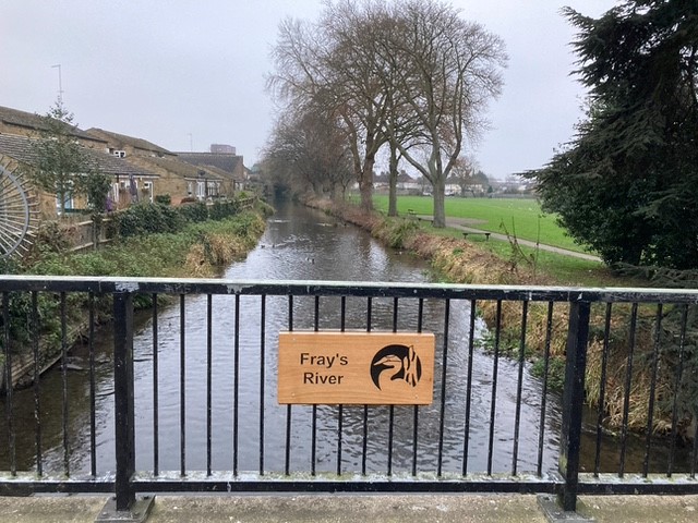
During the project we worked in conjunction with Black Park Shed and they have produced beautiful wooden carved signs for the rivers across Colne valley Regional Park. Black Park Shed is a community space for people to connect, converse and create; activities are based mainly around woodwork. After seeing their beautiful wood work, we commissioned them to produce hand carved wooden signs to be positioned over bridges and along footpaths to showcase the rivers. Check out the logo they produced. The signs have been put up by the River Misbourne, River Colne and Wraysbury River with more following when secured further locations. If you know of any locations which would like signs please contact us and let us know.
Want to get involved and volunteer?
Colne Valley Regional Park has an extensive network of rivers and watercourses, which is a key part of the history and geography of this area however it can be quite confusing to connect and identify the watercourses. We are looking to enhance public connection to the rivers through signage project but need you help to identify suitable locations for river signs.
Can you help identify good locations for river signs along your local river?
If you enjoyed searching for river sign locations and walking along river why not sign up to be a river ranger? There are many opportunities for the public to learn about their rivers as well as practically conserving and surveying their local watercourses through the River Ranger Project. For more information take a look here: River Rangers project or contact us for further information.


